- Call Us Today: 877-258-9335
- Email: info@auglaize.us


Ohio has the fourth-highest rail freight traffic in the country. The CSX Railroad is strategically located in Auglaize County to help effectively and efficiently move your business. CSX boasts 21,000 miles of track, access to 70 ports and the largest intermodal network in the U.S., and nationwide transloading and distribution services with 5,800 miles of that track within Ohio. CSX runs north and south through the eastern side of Auglaize County. Additionally, Auglaize County is served by the RJ Corman Railroad, which is a multi-state rail provider that runs through western Auglaize County.
Visit Our Website |
Auglaize County is home to the Neil Armstrong Airport, one of the top general aviation airports in the state of Ohio. This county airport, named after the first man to walk on the moon, Neil Armstrong, serves many corporate jets and recreational planes. The airport recently underwent significant expansion, and offers convenient private plane and jet access to a 5500 foot(1677 meters) runway with no landing fees. Since 1993, Auglaize County had $4.5 million in expenditures to improve and renovate the airport to better serve the businesses and clients that utilize the airport. Additionally, Neil Armstrong Airport provides freight services and hangar space and is located four miles (6.4 km) from US 33.
Visit Our Website |
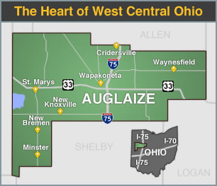
Auglaize County’s location at I-75 and US 33 helps you readily access your suppliers. Situated midway between I-70 and I-80/90 enables Auglaize County to be within one days trucking of 60% of the US population, 63% of all US retail operations, and 70% of all North American manufacturing.
Interstate access provides major benefits to in-state commerce with easy travel possible from any market in the state to another or beyond. More than 800 internationally owned companies from 43 countries depend on Ohio’s easy market access and established supply chains, including Honda, Bridgestone, Hitachi, Mitsubishi, Chrysler, Rolls-Royce, Mettler-Toledo and Nestle. Ohio exports now exceed $48 billion a year (+4.6% vs. 2011) and continue to grow.
View Our Maps Regional Drive Time Map |
Nine ports on Lake Erie and 16 terminals along the Ohio River rank Ohio the fourth-largest maritime state by tonnage moved. Because Ohio Port Authorities frequently offer both water and air transport, Ohio's maritime system proves a critical advantage in product transport. Auglaize County is located about midway between the Port of Toledo on Lake Erie and numerous terminals on the Ohio River near Cincinnati. Interstate 75 provides a direct link between both maritime options.
The Port of Toledo's Overseas Cargo Center provides 150 acres of ample warehouse and open storage along nearly one mile of straight-line wharf. It is served by gantry cranes along the entire wharf. Ships from throughout the world discharge and load the most diverse cargos of all the Great Lakes ports.
Visit Our Website |